WE ARE A LAND SURVEYING
& CIVIL ENGINEERING COMPANY PROVIDING CUTTING-EDGE TECHNOLOGY AND HIGH-QUALITY SERVICE
Welcome to Eagle Eye Land & Aerial Surveying Solutions, your trusted partner for precise land surveying and civil engineering services. As expert land surveyors and engineers, we specialize in property line surveys, topography surveys, drone surveying, and comprehensive civil engineering solutions.
Whether you're looking for a land surveyor or need expertly crafted engineering plans, we are dedicated to providing accurate measurements, detailed mapping, and innovative design solutions. At Eagle Eye, we redefine precision in surveying and engineering, offering comprehensive solutions for all your project needs.
At Eagle Eye, we pride ourselves on being your go-to land surveying experts. As seasoned land surveyors, our team is committed to delivering top-notch services tailored to your specific needs. From property line surveys to in-depth topography assessments, we employ cutting-edge technology, including drone surveying, to ensure precision and efficiency.
Our focus is on providing detailed and accurate results, whether you're inquiring about property survey costs or seeking a reliable land surveyor nearby. With a passion for excellence, we stand ready to redefine your expectations in land surveying, making us the trusted choice for all your property survey needs.
We boast highly skilled and certified land surveyors and drone pilots.
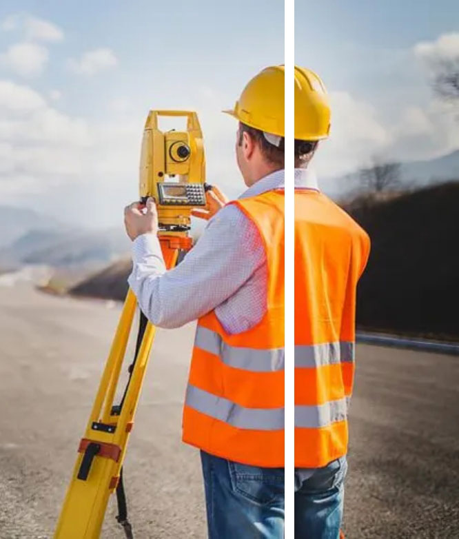
Boundary/topography surveys involve determining property boundaries and mapping the physical features of the land. Conducted by licensed surveyors, this data is essential for homeowners providing accurate information about property boundaries and land characteristics, and aiding in property management and decision-making.
Drone LiDAR Services
Drone LiDAR services use aerial technology to capture high-resolution data for mapping and surveying purposes. This technology, operated by licensed land surveying professionals, offers accurate topographical information and 3D mapping capabilities. landowners and developers benefit from precise data for property planning, infrastructure development, and environmental assessment.
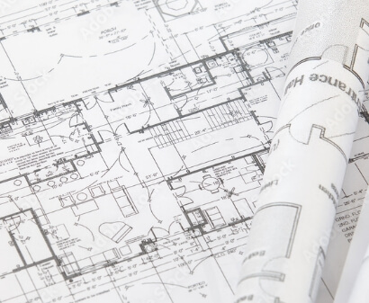
As-Built/Floor Plans
As-Built/floor plans are the documentation of the existing structure or building layout. Architects use these plans to provide accurate representation of current conditions, aiding in renovation, expansion, or new design projects. Contractors also leverage these detailed plans to streamline the construction processes, minimize errors, and ensure efficient project execution.
Civil Plans
Our Civil Plans Service provides comprehensive planning and design solutions tailored to your project's needs. Developed by experienced civil engineers, these plans outline critical site details, including grading, drainage, and infrastructure improvements, ensuring compliance with local regulations and optimal land use. Whether for residential, commercial, or municipal projects, our civil plans offer precise, well-structured guidance to support efficient construction, permitting, and long-term site sustainability.
Precise and Rough Grading Plans
Our Precise and Rough Grading Plans Service ensures proper land preparation for construction by establishing the ideal elevation, slope, and drainage flow. Rough grading sets the foundation by shaping the land to meet project specifications, while precise grading fine-tunes the surface for optimal stability and water runoff. Designed by experienced civil engineers, these plans are essential for preventing drainage issues, ensuring structural integrity, and meeting regulatory requirements for residential, commercial, and municipal developments.
Drainage Plans
Our Drainage Plans Service provides strategic water management solutions to prevent erosion, flooding, and structural damage. Designed by expert civil engineers, these plans outline efficient stormwater drainage systems, ensuring proper water flow and compliance with local regulations. Whether for residential, commercial, or municipal projects, our drainage plans help protect properties by mitigating water-related risks and promoting long-term site stability.
With a commitment to delivering detailed results and a focus on customer satisfaction, we stand out as the preferred choice for those seeking a reliable land surveyor near them, providing unparalleled service and value.
Professional
We pride ourselves on outstanding communication and the ability to excel under tight deadlines.
Experienced
With over 20 years of experience, Eagle Eye has seen it all and done it all. Through our combined years of service, you can trust us to complete your job quickly and accurately.
Fast
At Eagle Eye, we take pride in delivering swift and accurate land surveying services, ensuring efficiency without compromising precision in every project.
I have dealt with other companies and struggled with scheduling (months of backlog) and access (can’t get access to the actual surveyor to ask a question).
When I reached out to Eagle Eye I had already had an issue with a different survey provided by a company that did not record it properly.
We needed a survey done quickly in order to get approval from the City for our renovations. Michael was able to provide us with a complete survey within a week, and he was willing to make the cosmetic changes requested by the City, after the job was over! He is accessible, his prices are reasonable, and they did a great job! I highly recommend!!!
Stephanie Phung
Mike and his team were great to work with. We had a surprise requirement from the city and a tight construction license deadline for our house and they got out to us quick to make the deadline. Everyone else was going to take weeks. They also worked well with our architect to get what they needed to resubmit to the city. Big thanks!
Mukundh Pandian
Mike and Eagle Eye Survey helped us out of not 1 but 2 tight spots we were in with passing our inspection. First, when I called around getting quotes and timelines for availability I was being told 2-6 werks! I also needed just a very basic survey but was bring quoted things I knew were not necessary. When I spoke with Mike and explained my situation that we needed something quickly, Read More...
Julie Dominguez
Excellent Land Surveying Experience
I recently had the pleasure of working with Michael Profet from Eagle Eye Land & Aerial Surveying for a survey of my residential property, and I cannot recommend their services enough. From start to finish, the experience was exceptional, making the entire process easy, fast, and surprisingly affordable.
I have dealt with other companies and struggled with scheduling (months of backlog) and access (can’t get access to the actual surveyor to ask a question).
When I reached out to Eagle Eye I had already had an issue with a different survey provided by a company that did not record it properly.
Eagle Eye was a dream to work with.
I made the call and was scheduled within a reasonable time frame.
My quote was succinct and reasonable.
The crew arrived on time, was extremely polite to my family/neighbors and performed very efficiently.
My survey results were provided within a reasonable amount of time.
Most importantly, I had questions once I received the results. With previous companies I have struggled to actually be able to speak to the surveyor and get reasonable answers. In those cases I had to work through administrative staff as an intermediate third party never getting to speak to the actual surveyor. Less than ideal!
With Eagle Eye I only had to call and I was quickly connected with the Surveyor who was able to address all my questions. Quick and easy like it should be.
For all my future land survey needs Eagle Eye will be my only call. I urge you to save yourself some time and avoid my past experiences. Call Eagle Eye Land Surveying.
Jeffrey Binkley
Mike and Eagle Eye Survey helped us out of not 1 but 2 tight spots we were in with passing our inspection. First, when I called around getting quotes and timelines for availability I was being told 2-6 werks! I also needed just a very basic survey but was bring quoted things I knew were not necessary. When I spoke with Mike and explained my situation that we needed something quickly, he was out in 2 days and I had the report a day after. He was very straight forward giving me exactly what I needed and not "upselling" on services I did not need. While I would have given him 5 stars just for that, we ran into a setback issue with our inspection. Mike worked with my architect and the inspector on questions they had when fixing the issue. He even came back out quickly to resurvey after the changes had been made with a new report and without charing me a new survey fee. He is professional, fair, and expedited.
Julie Dominguez
Excellent Land Surveying Experience
I recently had the pleasure of working with Michael Profet from Eagle Eye Land & Aerial Surveying for a survey of my residential property, and I cannot recommend their services enough. From start to finish, the experience was exceptional, making the entire process easy, fast, and surprisingly affordable.
First and foremost, Michael's expertise and professionalism were evident from our initial consultation. He patiently listened to my requirements and provided valuable insights and suggestions to ensure accurate results. His attention to detail was truly impressive, as he meticulously surveyed every corner of my property, leaving no stone unturned.
Furthermore, the speed at which the survey was completed was astonishing. Michael and his team efficiently carried out the survey, utilizing their cutting-edge aerial surveying technology. This not only expedited the process but also provided comprehensive and accurate data, ensuring the utmost precision in the final results.
Finally, I must mention the affordability of their services. Land surveying can often be a costly endeavor, but Michael at Eagle Eye Land & Aerial Surveying offers competitive rates without compromising on quality. The level of service provided for the price paid was simply outstanding.
In conclusion, I wholeheartedly recommend Michael Profet and Eagle Eye Land & Aerial Surveying for any land surveying needs. Their expertise, efficiency, and affordability make them the go-to choice for accurate and reliable surveys. Whether you require a survey for a residential or commercial property, you can trust Michael and his team to deliver exceptional results. Don't hesitate to hire them - you won't be disappointed!